


Activity 2
Essential Question
- What are the effects of latitude on climate?
Background
Latitude is the most important explanation of climate on Earth. Latitude is directly related to the amount of sunlight that arrives at the Earth’s surface and how long it continues to arrive. The equator is the lowest latitude and receives sunlight directly throughout the year. The Arctic Circle and North Pole, and their counterparts in the southern hemisphere, receive no direct sunshine on their surface. There are four other elements also, but none as important as latitude. They include altitude above sea level. The thinner atmosphere at higher elevations has fewer molecules per unit of air to intercept solar energy or to transfer energy from the sun.
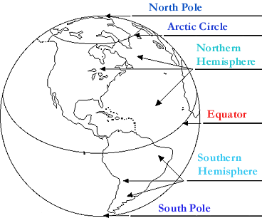
Proximity to large water and land bodies is the fifth major influence on climate. Large bodies of water tend to warm slowly and then radiate their energy slowly. They serve as cooling agents in early summer and warming agents in winter. Landmasses tend to warm quickly and then radiate their energy quite quickly. A good example is a desert that heats up quickly during the day, but cools off quickly in the evening. Of all these influences, latitude north and south of the equator is globally the most important.
Instructional Strategies
Strategy 1 |
Cause and Effect
Have students read the following passages. They tell the story of two weather observers at different latitudes. One is from Finland and the other one is from Kenya. Their daily recordings of weather are important information in classifying the climate of each place.
In 2004, Mrs. Rikkinin was still the weather observer. A new instrument box was near her house to replace the old one. It was filled with more modern equipment. Computer-operated instruments now read temperature, precipitation, wind, sunshine, air pollution, and ultra-violate rays from the Sun. The information is sent by radio signal to the national center in Helsinki. Today she records the weather conditions without having to step outside. That is unless it snows. Measuring snowfall is a regular task during Finland’s winter months. The chart shows the average temperatures over more than 40 years.
Jyvaskyla, Finland: Temperature (F) and Precipitation (Inches) Averages
|
City
|
Location
|
Data
|
J
|
F
|
M
|
A
|
M
|
J
|
J
|
A
|
S
|
O
|
N
|
D
|
| Jyvaskyla | 62N/26E | Ave. Temp | 15 | 15 | 23 | 34 | 47 | 57 | 60 | 57 | 47 | 38 | 28 | 20 |
| Total Precip. | 1.7 | 1.2 | 1.2 | 1.3 | 1.6 | 2.3 | 3.1 | 3.6 | 2.5 | 2.2 | 2.3 | 1.9 |
Nairobi, Kenya: Temperature (F) and Precipitation (Inches) Averages
|
City
|
Location
|
Data
|
J
|
F
|
M
|
A
|
M
|
J
|
J
|
A
|
S
|
O
|
N
|
D
|
| Nairobi | 1S/37E | Ave. Temp | 64 | 65 | 66 | 65 | 63 | 61 | 59 | 60 | 63 | 66 | 64 | 63 |
| Total Precip. | 1.9 | 4.2 | 3.7 | 8.3 | 5.2 | 2.0 | 0.8 | 0.9 | 0.9 | 2.0 | 5.8 | 3.5 |
Connections to Math:
- Calculate the total precipitation for the year for both places and record it (it is 39.2 inches for Kenya; 24.9 inches for Finland)
- Calculate the difference between the warmest month in Finland and the average temperature in Kenya during the same month (it is 1 degree F).
- Calculate the difference between the average temperature in February in Finland and the temperature during February in Kenya (it is 50 degrees F)
Cause and Effect:
Ask the students what the effects of latitude are on the differences between Finland and Kenya regarding:
- precipitation (not very much, since both places receive more than 25 inches of precipitation. In Finland that is adequate to grow evergreen forests, while in Kenya it is adequate for grasslands with scattered trees.
- temperature (50 degrees F. is a large difference in temperature between two places. For example, snow and ice would be present in Finland for most of the winter months, November – March.
Check for Understanding |
Printable Student View |
- Would it get colder or warmer as you travel from lower to higher latitudes, explain your answer?
Strategy 2 |
Application
The students may use resource books and the World Wide Web to research information that will help then associate climatic conditions with life roles. For example, freezing weather and precipitation in January in Finland will result in snow. That will make for icy roads and will affect the work of the Ambulance attendant. Write ideas and speculations in the chart below.
What will my life be like during the year?
|
Role
|
Nairobi-Latitude:
|
Jyvaskyla-Latitude:
|
| Ambulance Attendant | ||
| Construction Worker-outside | ||
| Airline Pilot | ||
| Middle School Student | ||
| National Park Ranger |
Check for Understanding |
Printable Student View |
The chart shows the annual average temperature for the coldest and warmest months for five cities in the United States.
Study the information and write a paragraph that states why the rule and table are in agreement; or why they disagree.
|
Temp/Precip
|
Duluth
|
Chicago
|
Nashville
|
Atlanta
|
Miami
|
| Coldest Month | 10 | 22 | 38 | 42 | 69 (Jan) |
| Warmest Month | 70 | 78 | 80 | 80 | 82 |
| Latitude | 47 N | 42 M | 36 N | 34 N | 26 N |
Rule: Increasing latitude has the effect of decreasing temperatures on Earth. This effect is there if you increase latitude north or south.