


Activity 1
Essential Question
- What is the difference between weather and climate?
Background
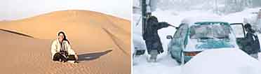
Weather is the day-to-day change in the state of the atmosphere, reflected by such statements as the weather is sunny today, or it is cloudy today. Climate is the long -term conditions of the atmosphere at a place, such as a desert. For example, Tucson is located in a desert climate. There is a slight chance it may rain on the day you visit, but most of the year it will be hot and dry, which are the long-term conditions of the climate. In Michigan in October people begin to prepare their homes and cars for very cold, snowy weather. They know the climate in winter brings cold temperatures. There may be some sunny, warm days, but overall the winter climate is cold.
Instructional Strategies
 |
Strategy 1 |
Concept Formation
Locate your school on a map of the United States. Ask students the location north of the equator in degrees (for example, Kalamazoo, MI is 42 degrees north).
Next, write the following questions on the board or an overhead transparency:
- What was the weather like yesterday?
- What is the weather like today?
- Is the weather like this every day?
Use a website such as this one to talk about the difference between weather and climate:
http://weather.about.com
- What are some of the day-to-day changes that occur with the weather?
- What descriptions do people in our community use to describe the weather?
- What are some key characteristics associated with the term “weather”? What are some key characteristics associated with the term “climate”?
Provide a copy of the T-Chart to each student. Note that on the T-Chart the classification “day to day” is on the left side heading and “long term” is on the right side.
Have the students work in pairs, to classify the short-term changes in the weather. For example, it may rain one day and be sunny the next. That is a “short term condition.” A change from warm (70 degrees) to hot (80 degrees) from one day to the next is a “short term condition.” Each pair should write two additional day-to-day conditions on the left hand column of the T-Chart.
After the short-term conditions of the atmosphere (day to day) have been listed on the T-Chart, ask:
- What months of the year do we wear warmer clothes than at other times?
- Are the weather conditions here (where we live) the same on June 21 and December 21?
- What are some of the long-term changes in temperature and precipitation that occur during the calendar year where we live? (Those changes may be related to sports, outdoor activities, traveling to school, high temperatures in summer, snow in winter, etc.)
Working in pairs, instruct the students to write two of the changes that occur in temperature and/or precipitation over time in the area of the United States where they live. Have them write these changes in the right hand side of the T-Chart. Encourage the students to use the terms temperature, precipitation and the names of the months or seasons in their statements.
At the bottom of the T-Chart beneath the columns have students write the word “Weather” beneath the left column, and beneath the right side have them write “Climate.”
Compare the day-to-day changes in the left column and the longer-term changes on the right column of the T-Chart.
|
Strategy 2 |
Graphic Organizers
Have students use the KWLH Chart to organize what they know about climate and weather and what they want to find out.
Use the NOAA Weather Map for the United States to learn more about weather in different part of the country: http://www.nws.noaa.gov/outlook_tab.html. Begin by selecting the National Map option in the menu along the top of the map.
Have the students work in pairs and follow these steps:
- Identify four places to be investigated for weather and write them on the KWLH Chart.
- What they want to find out about the weather at each place today.
- What the weather map told them about the weather and for what period of time (for example, for shorter than a day, for a day, for a week, etc.)
- How they can learn more about weather in other places using the URL.
Have students talk about the common features shown on most national weather maps. Discussion Questions:
- Why is precipitation so important to show on a national weather map?
- Why is temperature so important to show on a national weather map?
Check for Understanding |
Printable Student View |
Present the following short reading passage to the students.
- What terms are used to describe the day-to-day weather conditions in a place?
- What terms are used to describe the long-term weather conditions in a place?
- What are the phrases used in your home or in your town that describe the weather?
- What are the phrases used in your home or in your town that describes the climate?
- Based on the information you have, write a definition for weather and then write a definition for climate?